4. Existing data forms for your institution
Check which existing source fields can supply the decision inputs.
Reservoir · Water and irrigation
Existing form reference: 4c16fb03e60a6df6
| Field | Unit | Required |
|---|
| Source record ID | Confirm if needed | No |
| Tank Code | Confirm if needed | No |
| Reservoir name | Confirm if needed | No |
| Range Code | Confirm if needed | No |
| Range | Confirm if needed | No |
| Division Code | Confirm if needed | No |
| Division | Confirm if needed | No |
| Type | Confirm if needed | No |
| River basin | Confirm if needed | No |
| Scheme | Confirm if needed | No |
| HFL m MSL | m MSL | No |
| FSL m MSL | m MSL | No |
| BTL m MSL | m MSL | No |
| Catchment Area (ha) | ha | No |
| Capacity at FSL (MCM) | million m³ | No |
| Dead Storage (MCM) | million m³ | No |
| Live Storage (MCM) | million m³ | No |
| Area at FSL (ha) | ha | No |
| Capacity at FSL(Acft) | acre-ft | No |
| Dead Storage (Acft) | acre-ft | No |
| Live Storage (Acft) | acre-ft | No |
| Remarks | Confirm if needed | No |
| Source geometry area | Confirm if needed | No |
| Source geometry length | Confirm if needed | No |
Irrigable Area · Water and irrigation
Existing form reference: c16bd1e4f59a2a05
| Field | Unit | Required |
|---|
| Source record ID | Confirm if needed | No |
| Scheme | Confirm if needed | No |
| Type | Confirm if needed | No |
| Division | Confirm if needed | No |
| Range | Confirm if needed | No |
| Res An Uni | Confirm if needed | No |
| Code | Confirm if needed | No |
| Response Officer | Confirm if needed | No |
| Irrigable Area - Scheme Register (ha) | ha | No |
| Remarks | Confirm if needed | No |
| Source geometry area | Confirm if needed | No |
| Source geometry length | Confirm if needed | No |
Canal System · Water and irrigation
Existing form reference: 21d2e28388872fa1
| Field | Unit | Required |
|---|
| Source record ID | Confirm if needed | No |
| Scheme | Confirm if needed | No |
| Subsystem | Confirm if needed | No |
| Division | Confirm if needed | No |
| Range | Confirm if needed | No |
| Canal Type | Confirm if needed | No |
| Code | Confirm if needed | No |
| Res An Uni | Confirm if needed | No |
| Scheme Type | Confirm if needed | No |
| Source geometry length | Confirm if needed | No |
Bund · Water and irrigation
Existing form reference: a834d8c98d70c0a1
| Field | Unit | Required |
|---|
| OBJECTID 1 | Confirm if needed | No |
| Reservoir name | Confirm if needed | No |
| Division | Confirm if needed | No |
| Type | Confirm if needed | No |
| Range | Confirm if needed | No |
| Tank Code | Confirm if needed | No |
| Division Code | Confirm if needed | No |
| Bund Top Width (m) | Confirm if needed | No |
| Maximum Height of Bund (m) | Confirm if needed | No |
| Length of Bund (m) | Confirm if needed | No |
| Up Stream Slope | Confirm if needed | No |
| Down Stream Slope | Confirm if needed | No |
| Range Code | Confirm if needed | No |
| Source geometry length | Confirm if needed | No |
Tank Coordinate · Water and irrigation
Existing form reference: 1c6cf855f1769bc7
| Field | Unit | Required |
|---|
| Source record ID | Confirm if needed | No |
| X Coordinate (Em) | Confirm if needed | No |
| Y Coordinate (Nm) | Confirm if needed | No |
| Reservoir name | Confirm if needed | No |
| Division | Confirm if needed | No |
| Type | Confirm if needed | No |
| Range | Confirm if needed | No |
| Tank Code | Confirm if needed | No |
| Division Code | Confirm if needed | No |
| Range Code | Confirm if needed | No |
| SLD99 Xm | Confirm if needed | No |
| SLD99 Ym | Confirm if needed | No |
| Latitude | Confirm if needed | No |
| Longitude | Confirm if needed | No |
Sluice · Water and irrigation
Existing form reference: a4b6d5793605c038
| Field | Unit | Required |
|---|
| Location | Confirm if needed | No |
| Reservoir name | Confirm if needed | No |
| Reservoir Type | Confirm if needed | No |
| Range | Confirm if needed | No |
| Tank Code | Confirm if needed | No |
| Division Code | Confirm if needed | No |
| Range Code | Confirm if needed | No |
| Division | Confirm if needed | No |
| SLD99 Xm | Confirm if needed | No |
| SLD99 Ym | Confirm if needed | No |
| Latitiude | Confirm if needed | No |
| Longitude | Confirm if needed | No |
| Chinage Location | Confirm if needed | No |
| Sluice Sill Level | Confirm if needed | No |
| Number of Baral | Confirm if needed | No |
| Size of Baral | Confirm if needed | No |
| Remarks | Confirm if needed | No |
Spill · Water and irrigation
Existing form reference: 52df99673ebef8ff
| Field | Unit | Required |
|---|
| OBJECTID 12 | Confirm if needed | No |
| Location | Confirm if needed | No |
| Division | Confirm if needed | No |
| Tank Code | Confirm if needed | No |
| Reservoir name | Confirm if needed | No |
| Range | Confirm if needed | No |
| Type | Confirm if needed | No |
| Range Code | Confirm if needed | No |
| Division Code | Confirm if needed | No |
| SLD99 Xm | Confirm if needed | No |
| SLD99 Ym | Confirm if needed | No |
| Latitude | Confirm if needed | No |
| Longitude | Confirm if needed | No |
| Spill Location in Chainage(km+m) | Confirm if needed | No |
| Spill Type | Confirm if needed | No |
| Spill Length m | Confirm if needed | No |
| No of Gates | Confirm if needed | No |
| Type of Gate | Confirm if needed | No |
| Size of Gate m (W x H) | Confirm if needed | No |
| Spill Crest Level mMSL | Confirm if needed | No |
| Remarks | Confirm if needed | No |
| Comments | Confirm if needed | No |
river basins · Water and irrigation
Existing form reference: d2774621c4b33eb3
| Field | Unit | Required |
|---|
| OID | Confirm if needed | No |
| Name | Confirm if needed | No |
| FolderPath | Confirm if needed | No |
| SymbolID | Confirm if needed | No |
| AltMode | Confirm if needed | No |
| Base | Confirm if needed | No |
| Clamped | Confirm if needed | No |
| Extruded | Confirm if needed | No |
| Snippet | Confirm if needed | No |
| PopupInfo | Confirm if needed | No |
| Source geometry area | Confirm if needed | No |
| Source geometry length | Confirm if needed | No |
Attanagalu Oya Flood 2018; Deduru Oya Flood 2018; Gal Oya Flood 2016 · Flood Inundation DSD · Water and irrigation
Existing form reference: 0971c8cf24efd19e
| Field | Unit | Required |
|---|
| Source record ID | Confirm if needed | No |
| Join Count | Confirm if needed | No |
| TARGET FID | Confirm if needed | No |
| Province | Confirm if needed | No |
| province c | Confirm if needed | No |
| District | Confirm if needed | No |
| district c | Confirm if needed | No |
| Divisional secretariat | Confirm if needed | No |
| dsd c | Confirm if needed | No |
| Flood event / area | Confirm if needed | No |
| Source geometry area | Confirm if needed | No |
| Source geometry length | Confirm if needed | No |
Yan Oya Flood 2016 · Flood Inundation GND · Water and irrigation
Existing form reference: b2ee7829c7cfc34b
| Field | Unit | Required |
|---|
| Source record ID | Confirm if needed | No |
| Grama Niladhari division | Confirm if needed | No |
| gnd no | Confirm if needed | No |
| gnd c | Confirm if needed | No |
| Province | Confirm if needed | No |
| province c | Confirm if needed | No |
| District | Confirm if needed | No |
| district c | Confirm if needed | No |
| Divisional secretariat | Confirm if needed | No |
| dsd c | Confirm if needed | No |
| admin code | Confirm if needed | No |
| Flood event / area | Confirm if needed | No |
| Source geometry area | Confirm if needed | No |
| Source geometry length | Confirm if needed | No |
Yan Oya Flood 2016 · Flood Inundation DSD · Water and irrigation
Existing form reference: 71692320f67c8770
| Field | Unit | Required |
|---|
| Source record ID | Confirm if needed | No |
| Join Count | Confirm if needed | No |
| TARGET FID | Confirm if needed | No |
| Province | Confirm if needed | No |
| province c | Confirm if needed | No |
| District | Confirm if needed | No |
| district c | Confirm if needed | No |
| Divisional secretariat | Confirm if needed | No |
| dsd c | Confirm if needed | No |
| Flood event / area | Confirm if needed | No |
| Source geometry area | Confirm if needed | No |
| Source geometry length | Confirm if needed | No |
Yan Oya Flood 2016 · Flood Inundation Area · Water and irrigation
Existing form reference: 9d90cd9c5c84a7ba
| Field | Unit | Required |
|---|
| Source record ID | Confirm if needed | No |
| Flood event / area | Confirm if needed | No |
| Publisher label | Confirm if needed | No |
| Source geometry area | Confirm if needed | No |
| Source geometry length | Confirm if needed | No |
River Basin · source layer 81 · Water and irrigation
Existing form reference: 8ba4ffbddb26f7b5
| Field | Unit | Required |
|---|
| Source record ID | Confirm if needed | No |
| Watershed name | Confirm if needed | No |
| Wshed No | Confirm if needed | No |
| SubRivBasN | Confirm if needed | No |
| Sub RivBas | Confirm if needed | No |
| Area | Confirm if needed | No |
| Source geometry area | Confirm if needed | No |
| Source geometry length | Confirm if needed | No |
Nilwala Ganga Flood 2017 · Flood Inundation GND · Water and irrigation
Existing form reference: cd20f9bf8d1487c0
| Field | Unit | Required |
|---|
| Source record ID | Confirm if needed | No |
| Grama Niladhari division | Confirm if needed | No |
| gnd no | Confirm if needed | No |
| gnd c | Confirm if needed | No |
| Province | Confirm if needed | No |
| province c | Confirm if needed | No |
| District | Confirm if needed | No |
| district c | Confirm if needed | No |
| Divisional secretariat | Confirm if needed | No |
| dsd c | Confirm if needed | No |
| admin code | Confirm if needed | No |
| Flood event / area | Confirm if needed | No |
| Source geometry area | Confirm if needed | No |
| Source geometry length | Confirm if needed | No |
Nilwala Ganga Flood 2017 · Flood Inundation DSD · Water and irrigation
Existing form reference: d6e8e9a429825b57
| Field | Unit | Required |
|---|
| Source record ID | Confirm if needed | No |
| Join Count | Confirm if needed | No |
| TARGET FID | Confirm if needed | No |
| Province | Confirm if needed | No |
| province c | Confirm if needed | No |
| District | Confirm if needed | No |
| district c | Confirm if needed | No |
| Divisional secretariat | Confirm if needed | No |
| dsd c | Confirm if needed | No |
| Flood event / area | Confirm if needed | No |
| Source geometry area | Confirm if needed | No |
| Source geometry length | Confirm if needed | No |
Nilwala Ganga Flood 2017 · Flood Inundation Area · Water and irrigation
Existing form reference: ce6e0b46bd0534b9
| Field | Unit | Required |
|---|
| Source record ID | Confirm if needed | No |
| Flood event / area | Confirm if needed | No |
| Publisher label | Confirm if needed | No |
| Source geometry area | Confirm if needed | No |
| Source geometry length | Confirm if needed | No |
River Basin · source layer 76 · Water and irrigation
Existing form reference: 4d62429a56f1e52b
| Field | Unit | Required |
|---|
| Source record ID | Confirm if needed | No |
| Watershed name | Confirm if needed | No |
| Wshed No | Confirm if needed | No |
| SubRivBasN | Confirm if needed | No |
| Sub RivBas | Confirm if needed | No |
| Area | Confirm if needed | No |
| Source geometry area | Confirm if needed | No |
| Source geometry length | Confirm if needed | No |
Mundani Aru Flood 2014 · Flood Inundation GND · Water and irrigation
Existing form reference: 54b17c1b976d7b7c
| Field | Unit | Required |
|---|
| Source record ID | Confirm if needed | No |
| Grama Niladhari division | Confirm if needed | No |
| gnd no | Confirm if needed | No |
| gnd c | Confirm if needed | No |
| Province | Confirm if needed | No |
| province c | Confirm if needed | No |
| District | Confirm if needed | No |
| district c | Confirm if needed | No |
| Divisional secretariat | Confirm if needed | No |
| dsd c | Confirm if needed | No |
| admin code | Confirm if needed | No |
| Flood event / area | Confirm if needed | No |
| Source geometry area | Confirm if needed | No |
| Source geometry length | Confirm if needed | No |
Mundani Aru Flood 2014 · Flood Inundation DSD · Water and irrigation
Existing form reference: de66a3c339d43cc1
| Field | Unit | Required |
|---|
| Source record ID | Confirm if needed | No |
| Join Count | Confirm if needed | No |
| TARGET FID | Confirm if needed | No |
| Province | Confirm if needed | No |
| province c | Confirm if needed | No |
| District | Confirm if needed | No |
| district c | Confirm if needed | No |
| Divisional secretariat | Confirm if needed | No |
| dsd c | Confirm if needed | No |
| Flood event / area | Confirm if needed | No |
| Source geometry area | Confirm if needed | No |
| Source geometry length | Confirm if needed | No |
Mundani Aru Flood 2014 · Flood Inundation Area · Water and irrigation
Existing form reference: ebc817056ae98de6
| Field | Unit | Required |
|---|
| Source record ID | Confirm if needed | No |
| Flood event / area | Confirm if needed | No |
| Publisher label | Confirm if needed | No |
| Source geometry area | Confirm if needed | No |
| Source geometry length | Confirm if needed | No |
River Basin · source layer 71 · Water and irrigation
Existing form reference: 7df34748f8dc7a71
| Field | Unit | Required |
|---|
| Source record ID | Confirm if needed | No |
| Watershed name | Confirm if needed | No |
| Wshed No | Confirm if needed | No |
| SubRivBasN | Confirm if needed | No |
| Sub RivBas | Confirm if needed | No |
| Area | Confirm if needed | No |
| Source geometry area | Confirm if needed | No |
| Source geometry length | Confirm if needed | No |
Mee Oya Flood 2019 · Flood Inundation GND · Water and irrigation
Existing form reference: 336909700eb1e807
| Field | Unit | Required |
|---|
| Source record ID | Confirm if needed | No |
| Grama Niladhari division | Confirm if needed | No |
| gnd no | Confirm if needed | No |
| gnd c | Confirm if needed | No |
| Province | Confirm if needed | No |
| province c | Confirm if needed | No |
| District | Confirm if needed | No |
| district c | Confirm if needed | No |
| Divisional secretariat | Confirm if needed | No |
| dsd c | Confirm if needed | No |
| admin code | Confirm if needed | No |
| Flood event / area | Confirm if needed | No |
| Source geometry area | Confirm if needed | No |
| Source geometry length | Confirm if needed | No |
Mee Oya Flood 2019 · Flood Inundation DSD · Water and irrigation
Existing form reference: 977273349cc89bef
| Field | Unit | Required |
|---|
| Source record ID | Confirm if needed | No |
| Join Count | Confirm if needed | No |
| TARGET FID | Confirm if needed | No |
| Province | Confirm if needed | No |
| province c | Confirm if needed | No |
| District | Confirm if needed | No |
| district c | Confirm if needed | No |
| Divisional secretariat | Confirm if needed | No |
| dsd c | Confirm if needed | No |
| Flood event / area | Confirm if needed | No |
| Source geometry area | Confirm if needed | No |
| Source geometry length | Confirm if needed | No |
Mee Oya Flood 2019 · Flood Inundation Area · Water and irrigation
Existing form reference: 3c769ddf1cd69ffa
| Field | Unit | Required |
|---|
| Source record ID | Confirm if needed | No |
| Flood event / area | Confirm if needed | No |
| Publisher label | Confirm if needed | No |
| Source geometry area | Confirm if needed | No |
| Source geometry length | Confirm if needed | No |
River Basin · source layer 66 · Water and irrigation
Existing form reference: d6db0e029cc9024f
| Field | Unit | Required |
|---|
| Source record ID | Confirm if needed | No |
| Watershed name | Confirm if needed | No |
| Wshed No | Confirm if needed | No |
| SubRivBasN | Confirm if needed | No |
| Sub RivBas | Confirm if needed | No |
| Area | Confirm if needed | No |
| Source geometry area | Confirm if needed | No |
| Source geometry length | Confirm if needed | No |
Malwathu Oya Flood 2011 · Flood Inundation GND · Water and irrigation
Existing form reference: 17b96434d3bdc3d8
| Field | Unit | Required |
|---|
| Source record ID | Confirm if needed | No |
| Grama Niladhari division | Confirm if needed | No |
| gnd no | Confirm if needed | No |
| gnd c | Confirm if needed | No |
| Province | Confirm if needed | No |
| province c | Confirm if needed | No |
| District | Confirm if needed | No |
| district c | Confirm if needed | No |
| Divisional secretariat | Confirm if needed | No |
| dsd c | Confirm if needed | No |
| admin code | Confirm if needed | No |
| Flood event / area | Confirm if needed | No |
| Source geometry area | Confirm if needed | No |
| Source geometry length | Confirm if needed | No |
Malwathu Oya Flood 2011 · Flood Inundation DSD · Water and irrigation
Existing form reference: fa2f19c86d129c30
| Field | Unit | Required |
|---|
| Source record ID | Confirm if needed | No |
| Join Count | Confirm if needed | No |
| TARGET FID | Confirm if needed | No |
| Province | Confirm if needed | No |
| province c | Confirm if needed | No |
| District | Confirm if needed | No |
| district c | Confirm if needed | No |
| Divisional secretariat | Confirm if needed | No |
| dsd c | Confirm if needed | No |
| Flood event / area | Confirm if needed | No |
| Source geometry area | Confirm if needed | No |
| Source geometry length | Confirm if needed | No |
Malwathu Oya Flood 2011 · Flood Inundation Area · Water and irrigation
Existing form reference: 785418aca242c75f
| Field | Unit | Required |
|---|
| Source record ID | Confirm if needed | No |
| Flood event / area | Confirm if needed | No |
| Publisher label | Confirm if needed | No |
| Source geometry area | Confirm if needed | No |
| Source geometry length | Confirm if needed | No |
River Basin · source layer 61 · Water and irrigation
Existing form reference: 75f475250456de4c
| Field | Unit | Required |
|---|
| Source record ID | Confirm if needed | No |
| Watershed name | Confirm if needed | No |
| Wshed No | Confirm if needed | No |
| SubRivBasN | Confirm if needed | No |
| Sub RivBas | Confirm if needed | No |
| Area | Confirm if needed | No |
| Source geometry area | Confirm if needed | No |
| Source geometry length | Confirm if needed | No |
Mahaweli Ganga Flood 2012 · Flood Inundation GND · Water and irrigation
Existing form reference: 3d03fbdf1f36a8b0
| Field | Unit | Required |
|---|
| Source record ID | Confirm if needed | No |
| Grama Niladhari division | Confirm if needed | No |
| gnd no | Confirm if needed | No |
| gnd c | Confirm if needed | No |
| Province | Confirm if needed | No |
| province c | Confirm if needed | No |
| District | Confirm if needed | No |
| district c | Confirm if needed | No |
| Divisional secretariat | Confirm if needed | No |
| dsd c | Confirm if needed | No |
| admin code | Confirm if needed | No |
| Flood event / area | Confirm if needed | No |
| Source geometry area | Confirm if needed | No |
| Source geometry length | Confirm if needed | No |
Mahaweli Ganga Flood 2012 · Flood Inundation DSD · Water and irrigation
Existing form reference: 562d7edfae1efc39
| Field | Unit | Required |
|---|
| Source record ID | Confirm if needed | No |
| Join Count | Confirm if needed | No |
| TARGET FID | Confirm if needed | No |
| Province | Confirm if needed | No |
| province c | Confirm if needed | No |
| District | Confirm if needed | No |
| district c | Confirm if needed | No |
| Divisional secretariat | Confirm if needed | No |
| dsd c | Confirm if needed | No |
| Flood event / area | Confirm if needed | No |
| Source geometry area | Confirm if needed | No |
| Source geometry length | Confirm if needed | No |
Mahaweli Ganga Flood 2012 · Flood Inundation Area · Water and irrigation
Existing form reference: 5a3f22d6db739d31
| Field | Unit | Required |
|---|
| Source record ID | Confirm if needed | No |
| Flood event / area | Confirm if needed | No |
| Publisher label | Confirm if needed | No |
| Source geometry area | Confirm if needed | No |
| Source geometry length | Confirm if needed | No |
River Basin · source layer 56 · Water and irrigation
Existing form reference: bbc4c12de68b1c87
| Field | Unit | Required |
|---|
| Source record ID | Confirm if needed | No |
| Watershed name | Confirm if needed | No |
| Wshed No | Confirm if needed | No |
| SubRivBasN | Confirm if needed | No |
| Sub RivBas | Confirm if needed | No |
| Area | Confirm if needed | No |
| Source geometry area | Confirm if needed | No |
| Source geometry length | Confirm if needed | No |
Maha Oya (102) Flood 2016 · Flood Inundation GND · Water and irrigation
Existing form reference: ccd8becff516f214
| Field | Unit | Required |
|---|
| Source record ID | Confirm if needed | No |
| Grama Niladhari division | Confirm if needed | No |
| gnd no | Confirm if needed | No |
| gnd c | Confirm if needed | No |
| Province | Confirm if needed | No |
| province c | Confirm if needed | No |
| District | Confirm if needed | No |
| district c | Confirm if needed | No |
| Divisional secretariat | Confirm if needed | No |
| dsd c | Confirm if needed | No |
| admin code | Confirm if needed | No |
| Flood event / area | Confirm if needed | No |
| Source geometry area | Confirm if needed | No |
| Source geometry length | Confirm if needed | No |
Maha Oya (102) Flood 2016 · Flood Inundation DSD · Water and irrigation
Existing form reference: 388a6af26afd09cc
| Field | Unit | Required |
|---|
| Source record ID | Confirm if needed | No |
| Join Count | Confirm if needed | No |
| TARGET FID | Confirm if needed | No |
| Province | Confirm if needed | No |
| province c | Confirm if needed | No |
| District | Confirm if needed | No |
| district c | Confirm if needed | No |
| Divisional secretariat | Confirm if needed | No |
| dsd c | Confirm if needed | No |
| Flood event / area | Confirm if needed | No |
| Source geometry area | Confirm if needed | No |
| Source geometry length | Confirm if needed | No |
Maha Oya (102) Flood 2016 · Flood Inundation Area · Water and irrigation
Existing form reference: 9edb436b9dd89dbd
| Field | Unit | Required |
|---|
| Source record ID | Confirm if needed | No |
| Flood event / area | Confirm if needed | No |
| Publisher label | Confirm if needed | No |
| Source geometry area | Confirm if needed | No |
| Source geometry length | Confirm if needed | No |
River Basin · source layer 51 · Water and irrigation
Existing form reference: e86ead836ff90dea
| Field | Unit | Required |
|---|
| Source record ID | Confirm if needed | No |
| Watershed name | Confirm if needed | No |
| Wshed No | Confirm if needed | No |
| SubRivBasN | Confirm if needed | No |
| Sub RivBas | Confirm if needed | No |
| Area | Confirm if needed | No |
| Source geometry area | Confirm if needed | No |
| Source geometry length | Confirm if needed | No |
Kirama Oya Flood 2017 · Flood Inundation GND · Water and irrigation
Existing form reference: f589bf96735f0d23
| Field | Unit | Required |
|---|
| Source record ID | Confirm if needed | No |
| Grama Niladhari division | Confirm if needed | No |
| gnd no | Confirm if needed | No |
| gnd c | Confirm if needed | No |
| Province | Confirm if needed | No |
| province c | Confirm if needed | No |
| District | Confirm if needed | No |
| district c | Confirm if needed | No |
| Divisional secretariat | Confirm if needed | No |
| dsd c | Confirm if needed | No |
| admin code | Confirm if needed | No |
| Flood event / area | Confirm if needed | No |
| Source geometry area | Confirm if needed | No |
| Source geometry length | Confirm if needed | No |
Kirama Oya Flood 2017 · Flood Inundation DSD · Water and irrigation
Existing form reference: ab1ef79575b445fa
| Field | Unit | Required |
|---|
| Source record ID | Confirm if needed | No |
| Join Count | Confirm if needed | No |
| TARGET FID | Confirm if needed | No |
| Province | Confirm if needed | No |
| province c | Confirm if needed | No |
| District | Confirm if needed | No |
| district c | Confirm if needed | No |
| Divisional secretariat | Confirm if needed | No |
| dsd c | Confirm if needed | No |
| Flood event / area | Confirm if needed | No |
| Source geometry area | Confirm if needed | No |
| Source geometry length | Confirm if needed | No |
Kirama Oya Flood 2017 · Flood Inundation Area · Water and irrigation
Existing form reference: 5d056dd558b67b64
| Field | Unit | Required |
|---|
| Source record ID | Confirm if needed | No |
| Flood event / area | Confirm if needed | No |
| Publisher label | Confirm if needed | No |
| Source geometry area | Confirm if needed | No |
| Source geometry length | Confirm if needed | No |
River Basin · source layer 46 · Water and irrigation
Existing form reference: aa5a1be4d7f874a7
| Field | Unit | Required |
|---|
| Source record ID | Confirm if needed | No |
| Watershed name | Confirm if needed | No |
| Wshed No | Confirm if needed | No |
| SubRivBasN | Confirm if needed | No |
| Sub RivBas | Confirm if needed | No |
| Area | Confirm if needed | No |
| Source geometry area | Confirm if needed | No |
| Source geometry length | Confirm if needed | No |
Kalu Ganga Flood 2017 · Flood Inundation GND · Water and irrigation
Existing form reference: 23a2949aee5a9a33
| Field | Unit | Required |
|---|
| Source record ID | Confirm if needed | No |
| Grama Niladhari division | Confirm if needed | No |
| gnd no | Confirm if needed | No |
| gnd c | Confirm if needed | No |
| Province | Confirm if needed | No |
| province c | Confirm if needed | No |
| District | Confirm if needed | No |
| district c | Confirm if needed | No |
| Divisional secretariat | Confirm if needed | No |
| dsd c | Confirm if needed | No |
| admin code | Confirm if needed | No |
| Flood event / area | Confirm if needed | No |
| Source geometry area | Confirm if needed | No |
| Source geometry length | Confirm if needed | No |
Kalu Ganga Flood 2017 · Flood Inundation DSD · Water and irrigation
Existing form reference: 6adfb4fb98a8707e
| Field | Unit | Required |
|---|
| Source record ID | Confirm if needed | No |
| Join Count | Confirm if needed | No |
| TARGET FID | Confirm if needed | No |
| Province | Confirm if needed | No |
| province c | Confirm if needed | No |
| District | Confirm if needed | No |
| district c | Confirm if needed | No |
| Divisional secretariat | Confirm if needed | No |
| dsd c | Confirm if needed | No |
| Flood event / area | Confirm if needed | No |
| Source geometry area | Confirm if needed | No |
| Source geometry length | Confirm if needed | No |
Kalu Ganga Flood 2017 · Flood Inundation Area · Water and irrigation
Existing form reference: 0082696b49d69c10
| Field | Unit | Required |
|---|
| Source record ID | Confirm if needed | No |
| Flood event / area | Confirm if needed | No |
| Publisher label | Confirm if needed | No |
| Source geometry area | Confirm if needed | No |
| Source geometry length | Confirm if needed | No |
River Basin · source layer 41 · Water and irrigation
Existing form reference: 03a72f044ebae238
| Field | Unit | Required |
|---|
| Source record ID | Confirm if needed | No |
| Watershed name | Confirm if needed | No |
| Wshed No | Confirm if needed | No |
| SubRivBasN | Confirm if needed | No |
| Sub RivBas | Confirm if needed | No |
| Area | Confirm if needed | No |
| Source geometry area | Confirm if needed | No |
| Source geometry length | Confirm if needed | No |
Kelani Ganag Flood 2016 Major · Flood Inundation DSD · Water and irrigation
Existing form reference: fb02e7976de33449
| Field | Unit | Required |
|---|
| Source record ID | Confirm if needed | No |
| Join Count | Confirm if needed | No |
| TARGET FID | Confirm if needed | No |
| Province | Confirm if needed | No |
| province c | Confirm if needed | No |
| District | Confirm if needed | No |
| district c | Confirm if needed | No |
| Divisional secretariat | Confirm if needed | No |
| dsd c | Confirm if needed | No |
| Flood event / area | Confirm if needed | No |
| Source geometry area | Confirm if needed | No |
| Source geometry length | Confirm if needed | No |
Kelani Ganag Flood 2016 Major · Flood Inundation GND · Water and irrigation
Existing form reference: 03ee84fbf008e604
| Field | Unit | Required |
|---|
| Source record ID | Confirm if needed | No |
| Grama Niladhari division | Confirm if needed | No |
| gnd no | Confirm if needed | No |
| gnd c | Confirm if needed | No |
| Province | Confirm if needed | No |
| province c | Confirm if needed | No |
| District | Confirm if needed | No |
| district c | Confirm if needed | No |
| Divisional secretariat | Confirm if needed | No |
| dsd c | Confirm if needed | No |
| admin code | Confirm if needed | No |
| Flood event / area | Confirm if needed | No |
| Source geometry area | Confirm if needed | No |
| Source geometry length | Confirm if needed | No |
Kelani Ganag Flood 2016 Major · Flood Inundation Area · Water and irrigation
Existing form reference: 271b1d2b0a139a64
| Field | Unit | Required |
|---|
| Source record ID | Confirm if needed | No |
| Flood event / area | Confirm if needed | No |
| Publisher label | Confirm if needed | No |
| Source geometry area | Confirm if needed | No |
| Source geometry length | Confirm if needed | No |
River Basin · source layer 36 · Water and irrigation
Existing form reference: 7a5174dfa55bfd27
| Field | Unit | Required |
|---|
| Source record ID | Confirm if needed | No |
| Watershed name | Confirm if needed | No |
| Wshed No | Confirm if needed | No |
| SubRivBasN | Confirm if needed | No |
| Sub RivBas | Confirm if needed | No |
| Area | Confirm if needed | No |
| Source geometry area | Confirm if needed | No |
| Source geometry length | Confirm if needed | No |
Kelani Ganga Flood 2012 Minor · Flood Inundation GND · Water and irrigation
Existing form reference: cc5d99dd2a1894a4
| Field | Unit | Required |
|---|
| Source record ID | Confirm if needed | No |
| Grama Niladhari division | Confirm if needed | No |
| gnd no | Confirm if needed | No |
| gnd c | Confirm if needed | No |
| Province | Confirm if needed | No |
| province c | Confirm if needed | No |
| District | Confirm if needed | No |
| district c | Confirm if needed | No |
| Divisional secretariat | Confirm if needed | No |
| dsd c | Confirm if needed | No |
| admin code | Confirm if needed | No |
| Flood event / area | Confirm if needed | No |
| Source geometry area | Confirm if needed | No |
| Source geometry length | Confirm if needed | No |
Kelani Ganag Flood 2016 Minor · Flood Inundation DSD · Water and irrigation
Existing form reference: 620e0dab3654a548
| Field | Unit | Required |
|---|
| Source record ID | Confirm if needed | No |
| Join Count | Confirm if needed | No |
| TARGET FID | Confirm if needed | No |
| Province | Confirm if needed | No |
| province c | Confirm if needed | No |
| District | Confirm if needed | No |
| district c | Confirm if needed | No |
| Divisional secretariat | Confirm if needed | No |
| dsd c | Confirm if needed | No |
| Flood event / area | Confirm if needed | No |
| Source geometry area | Confirm if needed | No |
| Source geometry length | Confirm if needed | No |
Kelani Ganga Flood 2012 Minor · Flood Inundation Area · Water and irrigation
Existing form reference: 7f5d382712c12acf
| Field | Unit | Required |
|---|
| Source record ID | Confirm if needed | No |
| Flood event / area | Confirm if needed | No |
| Publisher label | Confirm if needed | No |
| Source geometry area | Confirm if needed | No |
| Source geometry length | Confirm if needed | No |
River Basin · source layer 31 · Water and irrigation
Existing form reference: 05802ebbb2056902
| Field | Unit | Required |
|---|
| Source record ID | Confirm if needed | No |
| Watershed name | Confirm if needed | No |
| Wshed No | Confirm if needed | No |
| SubRivBasN | Confirm if needed | No |
| Sub RivBas | Confirm if needed | No |
| Area | Confirm if needed | No |
| Source geometry area | Confirm if needed | No |
| Source geometry length | Confirm if needed | No |
Kelani Ganga Flood 1989 Critical · Flood Inundation GND · Water and irrigation
Existing form reference: 317acf986c000ec2
| Field | Unit | Required |
|---|
| Source record ID | Confirm if needed | No |
| Grama Niladhari division | Confirm if needed | No |
| gnd no | Confirm if needed | No |
| gnd c | Confirm if needed | No |
| Province | Confirm if needed | No |
| province c | Confirm if needed | No |
| District | Confirm if needed | No |
| district c | Confirm if needed | No |
| Divisional secretariat | Confirm if needed | No |
| dsd c | Confirm if needed | No |
| admin code | Confirm if needed | No |
| Flood event / area | Confirm if needed | No |
| Source geometry area | Confirm if needed | No |
| Source geometry length | Confirm if needed | No |
Kelani Ganga Flood 1989 Critical · Flood Inundation DSD · Water and irrigation
Existing form reference: a8bf89973a928788
| Field | Unit | Required |
|---|
| Source record ID | Confirm if needed | No |
| Join Count | Confirm if needed | No |
| TARGET FID | Confirm if needed | No |
| Province | Confirm if needed | No |
| province c | Confirm if needed | No |
| District | Confirm if needed | No |
| district c | Confirm if needed | No |
| Divisional secretariat | Confirm if needed | No |
| dsd c | Confirm if needed | No |
| Flood event / area | Confirm if needed | No |
| Source geometry area | Confirm if needed | No |
| Source geometry length | Confirm if needed | No |
Kelani Ganga Flood 1989 Critical · Flood Inundation Area · Water and irrigation
Existing form reference: 741b82a1161a09af
| Field | Unit | Required |
|---|
| Source record ID | Confirm if needed | No |
| Flood event / area | Confirm if needed | No |
| Publisher label | Confirm if needed | No |
| Source geometry area | Confirm if needed | No |
| Source geometry length | Confirm if needed | No |
River Basin · source layer 26 · Water and irrigation
Existing form reference: 3a83818903f3f37d
| Field | Unit | Required |
|---|
| Source record ID | Confirm if needed | No |
| Watershed name | Confirm if needed | No |
| Wshed No | Confirm if needed | No |
| SubRivBasN | Confirm if needed | No |
| Sub RivBas | Confirm if needed | No |
| Area | Confirm if needed | No |
| Source geometry area | Confirm if needed | No |
| Source geometry length | Confirm if needed | No |
Kala Oya Flood 2016 · Flood Inundation GND · Water and irrigation
Existing form reference: 49c3db841a10343f
| Field | Unit | Required |
|---|
| Source record ID | Confirm if needed | No |
| Grama Niladhari division | Confirm if needed | No |
| gnd no | Confirm if needed | No |
| gnd c | Confirm if needed | No |
| Province | Confirm if needed | No |
| province c | Confirm if needed | No |
| District | Confirm if needed | No |
| district c | Confirm if needed | No |
| Divisional secretariat | Confirm if needed | No |
| dsd c | Confirm if needed | No |
| admin code | Confirm if needed | No |
| Flood event / area | Confirm if needed | No |
| Source geometry area | Confirm if needed | No |
| Source geometry length | Confirm if needed | No |
Kala Oya Flood 2016 · Flood Inundation DSD · Water and irrigation
Existing form reference: 991636cb328c0e85
| Field | Unit | Required |
|---|
| Source record ID | Confirm if needed | No |
| Join Count | Confirm if needed | No |
| TARGET FID | Confirm if needed | No |
| Province | Confirm if needed | No |
| province c | Confirm if needed | No |
| District | Confirm if needed | No |
| district c | Confirm if needed | No |
| Divisional secretariat | Confirm if needed | No |
| dsd c | Confirm if needed | No |
| Flood event / area | Confirm if needed | No |
| Source geometry area | Confirm if needed | No |
| Source geometry length | Confirm if needed | No |
Kala Oya Flood 2016 · Flood Inundation Area · Water and irrigation
Existing form reference: b22dc6c49a5a6c32
| Field | Unit | Required |
|---|
| Source record ID | Confirm if needed | No |
| Flood event / area | Confirm if needed | No |
| Publisher label | Confirm if needed | No |
| Source geometry area | Confirm if needed | No |
| Source geometry length | Confirm if needed | No |
River Basin · source layer 21 · Water and irrigation
Existing form reference: 5aefbeaa988c678e
| Field | Unit | Required |
|---|
| Source record ID | Confirm if needed | No |
| Watershed name | Confirm if needed | No |
| Wshed No | Confirm if needed | No |
| SubRivBasN | Confirm if needed | No |
| Sub RivBas | Confirm if needed | No |
| Area | Confirm if needed | No |
| Source geometry area | Confirm if needed | No |
| Source geometry length | Confirm if needed | No |
Gin Ganga Flood 2017 · Flood Inundation GND · Water and irrigation
Existing form reference: aacfac87f71565b1
| Field | Unit | Required |
|---|
| Source record ID | Confirm if needed | No |
| Grama Niladhari division | Confirm if needed | No |
| gnd no | Confirm if needed | No |
| gnd c | Confirm if needed | No |
| Province | Confirm if needed | No |
| province c | Confirm if needed | No |
| District | Confirm if needed | No |
| district c | Confirm if needed | No |
| Divisional secretariat | Confirm if needed | No |
| dsd c | Confirm if needed | No |
| admin code | Confirm if needed | No |
| Flood event / area | Confirm if needed | No |
| Source geometry area | Confirm if needed | No |
| Source geometry length | Confirm if needed | No |
Gin Ganga Flood 2017 · Flood Inundation DSD · Water and irrigation
Existing form reference: 29a6fdf392f24335
| Field | Unit | Required |
|---|
| Source record ID | Confirm if needed | No |
| Join Count | Confirm if needed | No |
| TARGET FID | Confirm if needed | No |
| Province | Confirm if needed | No |
| province c | Confirm if needed | No |
| District | Confirm if needed | No |
| district c | Confirm if needed | No |
| Divisional secretariat | Confirm if needed | No |
| dsd c | Confirm if needed | No |
| Flood event / area | Confirm if needed | No |
| Source geometry area | Confirm if needed | No |
| Source geometry length | Confirm if needed | No |
Gin Ganga Flood 2017 · Flood Inundation Area · Water and irrigation
Existing form reference: a0692e188c7ae78c
| Field | Unit | Required |
|---|
| Source record ID | Confirm if needed | No |
| Flood event / area | Confirm if needed | No |
| Publisher label | Confirm if needed | No |
| Source geometry area | Confirm if needed | No |
| Source geometry length | Confirm if needed | No |
River Basin · source layer 16 · Water and irrigation
Existing form reference: 9f0e3d9806f9372e
| Field | Unit | Required |
|---|
| Source record ID | Confirm if needed | No |
| Watershed name | Confirm if needed | No |
| Wshed No | Confirm if needed | No |
| SubRivBasN | Confirm if needed | No |
| Sub RivBas | Confirm if needed | No |
| Area | Confirm if needed | No |
| Source geometry area | Confirm if needed | No |
| Source geometry length | Confirm if needed | No |
Gal Oya Flood 2016 · Flood Inundation GND · Water and irrigation
Existing form reference: 0896be503f933851
| Field | Unit | Required |
|---|
| Source record ID | Confirm if needed | No |
| Grama Niladhari division | Confirm if needed | No |
| gnd no | Confirm if needed | No |
| gnd c | Confirm if needed | No |
| Province | Confirm if needed | No |
| province c | Confirm if needed | No |
| District | Confirm if needed | No |
| district c | Confirm if needed | No |
| Divisional secretariat | Confirm if needed | No |
| dsd c | Confirm if needed | No |
| admin code | Confirm if needed | No |
| Flood event / area | Confirm if needed | No |
| Source geometry area | Confirm if needed | No |
| Source geometry length | Confirm if needed | No |
Gal Oya Flood 2016 · Flood Inundation DSD · Water and irrigation
Existing form reference: edc275f80f311458
| Field | Unit | Required |
|---|
| Source record ID | Confirm if needed | No |
| Join Count | Confirm if needed | No |
| TARGET FID | Confirm if needed | No |
| Province | Confirm if needed | No |
| province c | Confirm if needed | No |
| District | Confirm if needed | No |
| district c | Confirm if needed | No |
| Divisional secretariat | Confirm if needed | No |
| dsd c | Confirm if needed | No |
| Flood event / area | Confirm if needed | No |
| Source geometry area | Confirm if needed | No |
| Source geometry length | Confirm if needed | No |
Gal Oya Flood 2016 · Flood Inundation Area · Water and irrigation
Existing form reference: 621723d9774991dd
| Field | Unit | Required |
|---|
| Source record ID | Confirm if needed | No |
| Flood event / area | Confirm if needed | No |
| Publisher label | Confirm if needed | No |
| Source geometry area | Confirm if needed | No |
| Source geometry length | Confirm if needed | No |
River Basin · source layer 11 · Water and irrigation
Existing form reference: 66a5f593af6cf0f5
| Field | Unit | Required |
|---|
| Source record ID | Confirm if needed | No |
| Watershed name | Confirm if needed | No |
| Wshed No | Confirm if needed | No |
| SubRivBasN | Confirm if needed | No |
| Sub RivBas | Confirm if needed | No |
| Area | Confirm if needed | No |
| Source geometry area | Confirm if needed | No |
| Source geometry length | Confirm if needed | No |
Deduru Oya Flood 2018 · Flood Inundation DSD · Water and irrigation
Existing form reference: 7babdebde5c3a59f
| Field | Unit | Required |
|---|
| Source record ID | Confirm if needed | No |
| Join Count | Confirm if needed | No |
| TARGET FID | Confirm if needed | No |
| Province | Confirm if needed | No |
| province c | Confirm if needed | No |
| District | Confirm if needed | No |
| district c | Confirm if needed | No |
| Divisional secretariat | Confirm if needed | No |
| dsd c | Confirm if needed | No |
| Flood event / area | Confirm if needed | No |
| Source geometry area | Confirm if needed | No |
| Source geometry length | Confirm if needed | No |
Deduru Oya Flood 2018 · Flood Inundation GND · Water and irrigation
Existing form reference: 8ef6df7ed78bd257
| Field | Unit | Required |
|---|
| Source record ID | Confirm if needed | No |
| Grama Niladhari division | Confirm if needed | No |
| gnd no | Confirm if needed | No |
| gnd c | Confirm if needed | No |
| Province | Confirm if needed | No |
| province c | Confirm if needed | No |
| District | Confirm if needed | No |
| district c | Confirm if needed | No |
| Divisional secretariat | Confirm if needed | No |
| dsd c | Confirm if needed | No |
| admin code | Confirm if needed | No |
| Flood event / area | Confirm if needed | No |
| Source geometry area | Confirm if needed | No |
| Source geometry length | Confirm if needed | No |
Deduru Oya Flood 2018 · Flood Inundation Area · Water and irrigation
Existing form reference: 6e945531b3cfca82
| Field | Unit | Required |
|---|
| Source record ID | Confirm if needed | No |
| Flood event / area | Confirm if needed | No |
| Publisher label | Confirm if needed | No |
| Source geometry area | Confirm if needed | No |
| Source geometry length | Confirm if needed | No |
River Basin · source layer 6 · Water and irrigation
Existing form reference: ad60f9303374d50c
| Field | Unit | Required |
|---|
| Source record ID | Confirm if needed | No |
| Watershed name | Confirm if needed | No |
| Wshed No | Confirm if needed | No |
| SubRivBasN | Confirm if needed | No |
| Sub RivBas | Confirm if needed | No |
| Area | Confirm if needed | No |
| Source geometry area | Confirm if needed | No |
| Source geometry length | Confirm if needed | No |
Attanagalu Oya Flood 2018 · Flood Inundation GND · Water and irrigation
Existing form reference: f1156d2a9872139a
| Field | Unit | Required |
|---|
| Source record ID | Confirm if needed | No |
| Grama Niladhari division | Confirm if needed | No |
| gnd no | Confirm if needed | No |
| gnd c | Confirm if needed | No |
| Province | Confirm if needed | No |
| province c | Confirm if needed | No |
| District | Confirm if needed | No |
| district c | Confirm if needed | No |
| Divisional secretariat | Confirm if needed | No |
| dsd c | Confirm if needed | No |
| admin code | Confirm if needed | No |
| Flood event / area | Confirm if needed | No |
| Source geometry area | Confirm if needed | No |
| Source geometry length | Confirm if needed | No |
Attanagalu Oya Flood 2018 · Flood Inundation DSD · Water and irrigation
Existing form reference: 64d7a48f5360398d
| Field | Unit | Required |
|---|
| Source record ID | Confirm if needed | No |
| Join Count | Confirm if needed | No |
| TARGET FID | Confirm if needed | No |
| Province | Confirm if needed | No |
| province c | Confirm if needed | No |
| District | Confirm if needed | No |
| district c | Confirm if needed | No |
| Divisional secretariat | Confirm if needed | No |
| dsd c | Confirm if needed | No |
| Flood event / area | Confirm if needed | No |
| Source geometry area | Confirm if needed | No |
| Source geometry length | Confirm if needed | No |
Attanagalu Oya Flood 2018 · Flood Inundation Area · Water and irrigation
Existing form reference: 23c4010edccc9e62
| Field | Unit | Required |
|---|
| Source record ID | Confirm if needed | No |
| Flood event / area | Confirm if needed | No |
| Publisher label | Confirm if needed | No |
| Source geometry area | Confirm if needed | No |
| Source geometry length | Confirm if needed | No |
River Basin · source layer 1 · Water and irrigation
Existing form reference: 9cee3fab75edb4bf
| Field | Unit | Required |
|---|
| Source record ID | Confirm if needed | No |
| Watershed name | Confirm if needed | No |
| Wshed No | Confirm if needed | No |
| SubRivBasN | Confirm if needed | No |
| Sub RivBas | Confirm if needed | No |
| Area | Confirm if needed | No |
| Source geometry area | Confirm if needed | No |
| Source geometry length | Confirm if needed | No |
rivers · Water and irrigation
Existing form reference: bddcc1162ffe3b29
| Field | Unit | Required |
|---|
| OID | Confirm if needed | No |
| Name | Confirm if needed | No |
| FolderPath | Confirm if needed | No |
| SymbolID | Confirm if needed | No |
| AltMode | Confirm if needed | No |
| Base | Confirm if needed | No |
| Clamped | Confirm if needed | No |
| Extruded | Confirm if needed | No |
| Snippet | Confirm if needed | No |
| PopupInfo | Confirm if needed | No |
| Source geometry length | Confirm if needed | No |
Buffer of hydrostations · Water and irrigation
Existing form reference: a0f586c57ced7d89
| Field | Unit | Required |
|---|
| Source record ID | Confirm if needed | No |
| no | Confirm if needed | No |
| station | Confirm if needed | No |
| latitude | Confirm if needed | No |
| longitude | Confirm if needed | No |
| basin | Confirm if needed | No |
| Buffer distance in Meters | Confirm if needed | No |
| ORIG FID | Confirm if needed | No |
| Area in Square Kilometers | Confirm if needed | No |
| Source geometry area | Confirm if needed | No |
| Source geometry length | Confirm if needed | No |
gauges · Water and irrigation
Existing form reference: 10375802bd0f4154
| Field | Unit | Required |
|---|
| Source record ID | Confirm if needed | No |
| River Basin | Confirm if needed | No |
| Gauge | Confirm if needed | No |
| Water Level | station unit; select a station | No |
| Rain Fall | mm | No |
| Source record created | Confirm if needed | No |
| Source record edited | Confirm if needed | No |
| alertpull | station unit; select a station | No |
| minorpull | station unit; select a station | No |
| majorpull | station unit; select a station | No |
stations · Water and irrigation
Existing form reference: c0d33ca136364cb4
| Field | Unit | Required |
|---|
| Source record ID | Confirm if needed | No |
| no | Confirm if needed | No |
| station | Confirm if needed | No |
| latitude | Confirm if needed | No |
| longitude | Confirm if needed | No |
| basin | Confirm if needed | No |
| Tributory | Confirm if needed | No |
| Alert Level | Confirm if needed | No |
| Minor Flood Level | Confirm if needed | No |
| Major Flood Level | Confirm if needed | No |
| Unit | Confirm if needed | No |
| Elivation m MSL | m MSL | No |
groupbySummary · Water and irrigation
Existing form reference: 6a3ee4ad7513e95e
| Field | Unit | Required |
|---|
| Source record ID | Confirm if needed | No |
| Join ID | Confirm if needed | No |
| gauge | Confirm if needed | No |
| Sum Rain Fall | mm | No |
| Count of Points | Confirm if needed | No |
Irrigable Area · Water and irrigation
Existing form reference: ec64c51bcb7a13ab
Reservoir · Water and irrigation
Existing form reference: a4a0cc679fd52fa5
Bund · Water and irrigation
Existing form reference: 1f490c8006777e68
Sluice · Water and irrigation
Existing form reference: 1799548d75c1577b
Spill · Water and irrigation
Existing form reference: 092220ad7d168ad3
Canal System · Water and irrigation
Existing form reference: 018e6b3de43e55a7
Flood 30Nov2025 · source layer 0 · Water and irrigation
Existing form reference: d7be90171f7bd605
| Field | Unit | Required |
|---|
| OBJECTID 1 | Confirm if needed | No |
| RiverBasin | Confirm if needed | No |
| Source geometry area | Confirm if needed | No |
| Source geometry length | Confirm if needed | No |
Major reservoirs · current readings · Water and irrigation
Existing form reference: 2942a78ac9121012
| Field | Unit | Required |
|---|
| Publisher reservoir ID | Confirm if needed | No |
| Week No | Confirm if needed | No |
| Update Date | Confirm if needed | No |
| Reservoir | Confirm if needed | No |
| Latitude | Confirm if needed | No |
| Longitude | Confirm if needed | No |
| Range | Confirm if needed | No |
| Division | Confirm if needed | No |
| Irrigable area | acres | No |
| Full supply depth | ft | No |
| Gross Capacity Acft | acre-ft | No |
| Dead Storage Acft | acre-ft | No |
| Active Storage Acft | acre-ft | No |
| Date | Confirm if needed | No |
| Water Depth ft | ft | No |
| Gross Storage Acft | acre-ft | No |
| Effective Storage Acft | acre-ft | No |
| Effective storage percentage | % | No |
| Preceding-day rainfall | mm | No |
| Spilling | Confirm if needed | No |
| Remarks | Confirm if needed | No |
| Downstream impact | Confirm if needed | No |
| Spill discharge | cusec (publisher) | No |
| Remaining storage (publisher) | acre-ft | No |
Major reservoirs · Maha seasonal history · Water and irrigation
Existing form reference: 620e4a73d4ea0be0
| Field | Unit | Required |
|---|
| Publisher reservoir ID | Confirm if needed | No |
| UPDATED DATE | Confirm if needed | No |
| RESERVOIR | Confirm if needed | No |
| LATITUDE | Confirm if needed | No |
| LONGITUDE | Confirm if needed | No |
| RANGE | Confirm if needed | No |
| Division | Confirm if needed | No |
| Active Storage (Acft) | acre-ft | No |
| Long-term average | acre-ft | No |
| ES 20 21 Acft | acre-ft | No |
| ES 21 22 Acft | acre-ft | No |
| ES 22 23 Acft | acre-ft | No |
| ES 23 24 Acft | acre-ft | No |
| ES 24 25 Acft | acre-ft | No |
| ES 25 26 Acft | acre-ft | No |
| ES 26 27 Acft | acre-ft | No |
Major reservoirs · Yala seasonal history · Water and irrigation
Existing form reference: 560087607361a247
| Field | Unit | Required |
|---|
| ID | Confirm if needed | No |
| Publisher reservoir ID | Confirm if needed | No |
| UPDATED DATE | Confirm if needed | No |
| RESERVOIR | Confirm if needed | No |
| LATITUDE | Confirm if needed | No |
| LONGITUDE | Confirm if needed | No |
| RANGE | Confirm if needed | No |
| Division | Confirm if needed | No |
| Active Storage (Acft) | acre-ft | No |
| Long-term average | acre-ft | No |
| EFFECTIVE STORAGE (Acft) 2022 | acre-ft | No |
| EFFECTIVE STORAGE (Acft) 2023 | acre-ft | No |
| EFFECTIVE STORAGE (Acft) 2024 | acre-ft | No |
| EFFECTIVE STORAGE (Acft) 2025 | acre-ft | No |
| EFFECTIVE STORAGE (Acft) 2026 | acre-ft | No |
Medium reservoirs · Yala seasonal history · Water and irrigation
Existing form reference: c349e5c98d02782a
| Field | Unit | Required |
|---|
| Publisher reservoir ID | Confirm if needed | No |
| Update Date | Confirm if needed | No |
| Reservoir | Confirm if needed | No |
| Latitude | Confirm if needed | No |
| Longitude | Confirm if needed | No |
| Range | Confirm if needed | No |
| Division | Confirm if needed | No |
| Active Storage (Acft) | acre-ft | No |
| Long-term average | acre-ft | No |
| EFFECTIVE STORAGE (Acft) 2023 | acre-ft | No |
| EFFECTIVE STORAGE (Acft) 2024 | acre-ft | No |
| EFFECTIVE STORAGE (Acft) 2025 | acre-ft | No |
| EFFECTIVE STORAGE (Acft) 2026 | acre-ft | No |
Medium reservoirs · Maha seasonal history · Water and irrigation
Existing form reference: ade3b5a99ab49e1d
| Field | Unit | Required |
|---|
| Publisher reservoir ID | Confirm if needed | No |
| Update Date | Confirm if needed | No |
| Reservoir | Confirm if needed | No |
| Latitude | Confirm if needed | No |
| Longitude | Confirm if needed | No |
| Range | Confirm if needed | No |
| Division | Confirm if needed | No |
| Active Storage (Acft) | acre-ft | No |
| Long-term average | acre-ft | No |
| ES 24 25 Acft | acre-ft | No |
| ES 25 26 Acft | acre-ft | No |
| ES 26 27 Acft | acre-ft | No |
Medium reservoirs · current readings · Water and irrigation
Existing form reference: 78fedd1e1892ca18
| Field | Unit | Required |
|---|
| Publisher reservoir ID | Confirm if needed | No |
| Week No | Confirm if needed | No |
| Update Date | Confirm if needed | No |
| Reservoir | Confirm if needed | No |
| Latitude | Confirm if needed | No |
| Longitude | Confirm if needed | No |
| Range | Confirm if needed | No |
| Division | Confirm if needed | No |
| Irrigable area | acres | No |
| Full supply depth | ft | No |
| Gross Capacity Acft | acre-ft | No |
| Dead Storage Acft | acre-ft | No |
| Active Storage Acft | acre-ft | No |
| Date | Confirm if needed | No |
| Water Depth ft | ft | No |
| Gross Storage Acft | acre-ft | No |
| Effective Storage Acft | acre-ft | No |
| Effective storage percentage | % | No |
| Preceding-day rainfall | mm | No |
| Spilling | Confirm if needed | No |
| Remarks | Confirm if needed | No |
| Remaining storage (publisher) | acre-ft | No |
Published project technical details · Water and irrigation
Existing form reference: official-projects
| Field | Unit | Required |
|---|
| Project | Confirm if needed | No |
| Component | Confirm if needed | No |
| Parameter | Confirm if needed | No |
| Source page | Confirm if needed | No |
Irrigation publications · Water and irrigation
Existing form reference: official-publications
| Field | Unit | Required |
|---|
| Publication | Confirm if needed | No |
| Type | Confirm if needed | No |
| Publication period | Confirm if needed | No |
| Data availability | Confirm if needed | No |
| Publisher document | Confirm if needed | No |
6. Data structure management
Data structure keeps the existing source tree, records, charts and map. Manage structure adds a place to propose changes to definitions.
Open this screen for Irrigation DepartmentSee the presentation example
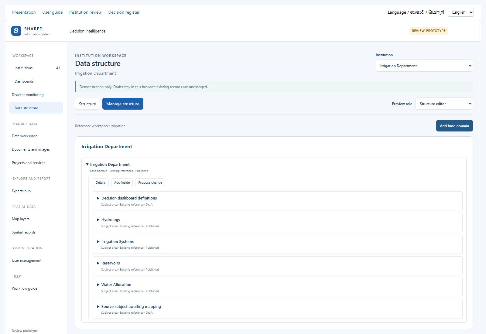 Irrigation Department. Prototype screen. Select the image to enlarge it.
What you can try
- Open Data structure and choose Manage structure.
- Use Add base domain for a main information area. Add inside creates a subject area, a nested subject, an entity type or a field under the right parent.
- Give the definition a clear name, code and meaning. Reuse an existing definition when the meaning is the same.
- For a field, check the data type, unit, required value, limits and missing-value rule. Save a Draft, then try the separate reviewer view.
An entity type means a kind of thing or event, such as a reservoir or an inspection. Drafts stay in this browser. A demo approval does not change real definitions, data, chart links or sharing rights.
What your institution needs to confirm
7. Users and access
User management shows example profiles for each institution. People and Roles and access let you review the proposed account screens.
Open this screen for Irrigation DepartmentSee the presentation example
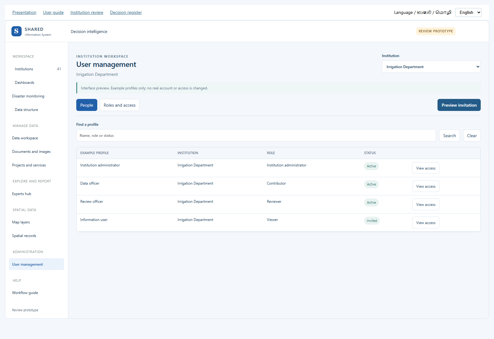 Irrigation Department. Prototype screen. Select the image to enlarge it.
What you can try
- Open User management and choose the institution. The rows are examples, not a list of your staff.
- Use View access to check a role. An administrator title alone does not give access to Private files.
- Try Preview invitation or Preview access change. Check the role, start date, optional end date and reason.
- Review the example permissions and tell us which job roles should receive each one.
These are interface previews only. They create no account, send no email and change no access. Use example details in the preview. Institution verification does not grant a real permission.
What your institution needs to confirm